A research project has demonstrated that bus routes could be mapped in Abidjan by just following anonymously the signal from the users’ handphones. Bus routes in third world countries are notoriously not centrally managed and operated by a large number of autonomous parties.
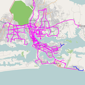
This mapping allows city planners to get an up-to-date picture of the situation and take action to improve the current situation or take other actions related to improving the traffic condition.
According to this research done by IBM, actions could be taken to slash commute time by more than 10%! (more on this in this BBC post).
Using available data that way, through the unaware collaboration of millions of commuters, is an effective way to create value for the community. How much of this would have been possible even 5 years ago?
